

Using Random Forests to predict neutral density
Sorry I couldn't come up with a better title/headline

One of our most recent papers utilizes machine learning to predict the neutral density at an altitude of 400 km. Okay - I’ve probably already lost you… But I swear you should care.
Let’s back up and talk about space. Space is a valuable place. In low Earth orbit, often referred to as LEO (less than about 2000 km or 1200 miles above the Earth), you can go around the world in something between 90 and 130 minutes (depending on your altitude). That’s insane. It’s also why we keep hearing about space planes and the like. Just imagine being able to go from Washington, DC to Sydney in 90 minutes! I could stock up on Vegemite whenever I need it! However, on a more serious note, the space economy in LEO is estimated to be over $400 billion. This is not a small investment. And I don’t think that this includes the economic impact these satellites have on industries a bit closer to the Earth, such as precision farming, banking, aviation, or mining.
Space is also a vulnerable place. There is a significant amount of debris in space. As of May 5, 2025, more than 14,000 tonnes of material are in orbit around the Earth. And ESA estimates that there have been over 650 break-ups, explosions, collisions, or anomalous events resulting in fragmentation. The more we have, the more frequently it is likely to increase. This is called the Kessler Syndrome. As we accumulate more debris, the more maneuvers and oversight a satellite will require to orbit safely in space. This combines two topics that are interconnected but often discussed separately: the orbital debris problem and satellite drag.
Orbital debris is a problem because, well, as the name suggests, it’s debris. This can be made up of anything. This could be paint flecks or whole decommissioned or dead satellites. It can be hammers, gloves, or nuts and bolts. It can be random pieces from collisions, and yes, all of it is important to track, especially as we expect more human activity in space. Even small debris can have significant impacts due to the speed at which it travels in orbit. Just take a look at the Hubble solar panels!
Debris cannot be moved easily, so you currently have to move around it if possible. But many are working on ways to help remove the debris from orbit. Some with lasers. Others are attaching a satellite/robot with thrusters to bring it back down to Earth. And even more ideas about harpoons or nets to gather the debris
But the debris can come down naturally too - and this natural process can also impact ongoing satellites… through drag.
We often think of the region where satellites live as empty space. However, in reality, the atmosphere is still present, just much less dense than on Earth. And like any atmosphere, or any material, it can slow you down as you move through it.
Let’s take one step back and think about orbiting. In LEO, orbiting is more of a fancy falling… where you never quite make it down to Earth. This is, of course, assuming that there is no air resistance. But that’s the catch. In LEO, there is still air - well, an atmosphere - and thus air resistance. You will often hear about satellites needing a boost. They need that boost because air resistance, or drag, slows them down. As the satellite slows down, it begins to fall closer to Earth, where it will eventually require a boost to return to its intended altitude. We call this process satellite drag. And of course, this drag doesn’t just impact the satellites, but also the debris in space.
There are two significant contributors to drag: the shape of the object and the density of the atmosphere. The shape of the object is often proprietary, or even if not, it can sometimes be challenging to obtain with absolute accuracy. And this shape is likely to be different from one user’s needs to the next. But the atmosphere. That is something that many research scientists can examine and attempt to predict. Then, a satellite operator, or someone tracking debris, can use the atmospheric estimates and tailor their needs to the satellite or object they are trying to track.
If the atmosphere were always the same, this would be a significant problem, but not a major one. If the atmosphere never changed, we would know how much drag there would be and thus could predict (almost perfectly) the impact on a satellite or an article of debris. But nature is never that kind to us. Weather in space and weather here on Earth can all change the atmosphere at the location of satellite orbits. These changes can occur over a decade or more, or they may happen much more quickly, on the order of seconds to minutes. To make the problem even harder - it’s difficult, if not near on impossible, to get data from some of the crucial regions impacting this problem… like the region where the atmosphere is too thin for balloons to fly but too thick for satellites to orbit for any length of time (~40km - 250km).
This problem at times seems insurmountable. But the beauty of science is that you can take one step, one small part of the problem, and make a start - kind of like most things in life. So with our paper, we do just that. We start with just one step, one small part of the problem, and determine if it might help us move forward with the larger issue at hand.
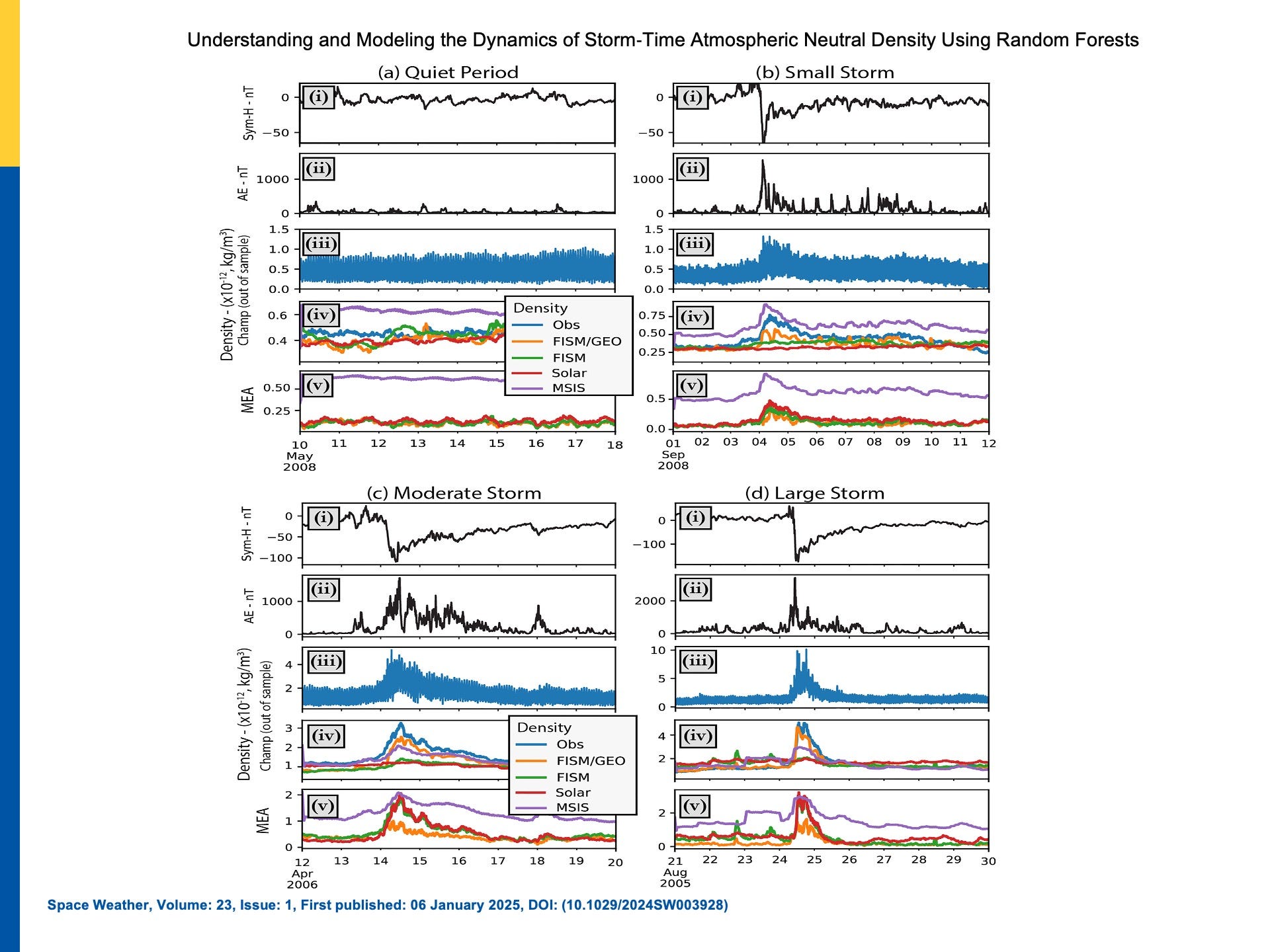
Many of the models currently used to determine the atmosphere utilize inputs from the Sun and the ionosphere itself. Many didn’t use the higher time resolution data from the magnetosphere. And every time we talked to an end user, they complained that their most significant errors occurred during geomagnetic storms. Now, my collaborator Kyle and I are not physics-based modelers. We prefer to work with data. Lots of data. Like lots and lots of data… all the data we can find. And so we did just that. We asked whether the inclusion of geomagnetic data could help us predict the neutral density at 400 km.
Again, why 400 km? Well, a couple of reasons. There aren’t that many satellites that can measure neutral atmospheric density, and they all fly at different altitudes. To take that first small step and ensure we had as much data as possible to examine, we used the standard normalization that many in our field employ. This enables us to compare and combine data from different satellites more easily. It’s also a nice altitude as many satellites fly in this region. We expect that if the atmospheric density is increasing at 400km, it’s likely rising for many of the satellites in orbit.
We created many models… but as with most science, you show the most direct storyline, not all the work and failures behind it. In the paper, we present three models, two of which are based solely on solar inputs, and one that includes geomagnetic activity proxies. And unsurprisingly to us, the one with the geomagnetic activity proxies did the best. Surprisingly, it performed better than one of the most commonly used models in operations. To be fair, it’s well known to be one of the models that doesn’t perform well, but it’s still a model that's frequently used.
There’s still a lot to do. And you will likely see more posts on these sets of models and their future versions. However, we have taken the initial step of creating a model that provides value in understanding, predicting, and, hopefully, one day, helping to protect our space-based assets.